![]()

 |
ACRE
|
A symbol of peace and hope, this flag was idealized by José Plácido de Castro who adopted the former flag, created by Dom Luiz Galvez Rodrigues de Arias, adding initastarashad suggested Colonel Rodrigo de Carvalho, the intellectual author of the last revolutions of this state.
This flag was officially adopted by the Governor of the ex- territory of Acre (nowadays State of Acre), Epaminondas Jácome.
Acre is a state in western Brazil, bordered by Peru on the west and south and Bolivia on the east. Located in the rain-forest zone. Acre was ceded to Bolivia by Brazil in 1867, but it was settled in the late 19th century by Brazilian rubber gatherers who declared Acre an independent nation in 1899. Acre was reannexed to Brazil as a territory in 1903, and it became a state in 1962
 |
AMAPACapital: Macapá |
 |
AMAZONASCapital: Manaus |
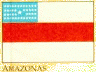
The Flag is constituted of 3 horizontal stripes in the colors red and white, so that 2 white stripes border the red Strine The stripes have the same length of the Flag, excepting the first stripe, the length of which is shortened to correspond to the blue rectangle situated at the superior left side of the Flag.
Upon the blue rectangle appear 25 stars in silver, representing by symbols the number of the municipalities existing on August 4th, 1897 and signifying the historical moment of the embarkment of the Military Forces of Amazonas to fight at Canudos.
The stars have sizes of first and second grandeur. I n the center of the rectangle appears the star of first grandeur representing the municipality of Manaus. The other municipalities are represented by stars of second grandeur placed in horizontal lines of four rows.
| Amazon quick-look LANDSAT
images Manaus Manaus |
 |
PARÁCapital: Belém |
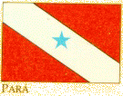
The Republic of Pará was proclaimed on 16th November 1689, and in the following year, the Municipal Council of this state accepted the proposal of its President, Artur Indio do Brasil recognizing the flag of the Republican Club as the official flag of the Municipality of Belém.
Afterward, the traditional symbol of the republicans was adopted as the flag of the Pará State.
The flag is formed by a red rectangle crossed by a white inclined stripe which descends from the left top to the right (45 degrees of deviation), having a blue star in its middle. The white stripe is the imaginary planetary belt representing the zodiac. The star is of magnitude 1.0 and belongs to the constellation of Virgo.
The red color symbolizes the vigor that is in the blood of the "Paraense" people.
The city's recent growth has been stimulated by improved transportation connections.
The Belém-Brasilia Highway, completed in 1960, runs 2,350 km (1,460 mi) in an almost straight north-south line between the two cities. A state university, several newspapers, and the large, white marble Paz Theater serve the educational and cultural needs of the people.
Belém, founded by the Portuguese in 1616, was the focus of several economic booms thereafter
Links to Pará and its cities...
Belém
Ministério Público do Estado do
Pará
 |
RONDONIACapital: Porto Velho |
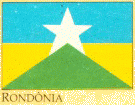
The upper half of the rectangle, lengthy, is blue. The five-equidistant-point-star is placed at the center of the flag. The surface formed by the lower points of the star, from the center to the inferior edges of the rectangle is green. The two equal polygons in the right and in the left sides of the star are yellow-gold.
Using four of the colors of the National Pavilion, the flag of Rondonia synthesizes the creation of the New State itself: "it is the newest star shining in the sky of the Union".
| RONDÔNIA
Elevado de Território ŕ categoria de Estado da Federaçăo pela Lei n.° 136, de 20 de dezembro de 1981, o recém-criado Estado de Rondônia delineia-se com promissoras perspectivas de expansăo econômica, dada a excelente qualidade de suas terras e clima. A ocupaçăo deste que é hoje o mais novo Organismo Político- administrativo brasileiro foi iniciada no século XVII, a partir da penetraçăo de portugueses na regiăo amazônica. Os pioneiros colonizadores seguiram as trilhas inicialmente abertas pelos padres j esuítas que vinham em em busca de riquezas naturais. A descoberta de jazidas auríferas no vale do Guaporé provocou o surgimento dos primeiros núcleos urbanos. O segundo surto de colonizaçăo aconteceu somente no século XX, provocado ao fim do período áureo da borracha. Com a construçăo da estrada de ferro Madeira-Mamoré, apareceram novos núcleos populacionais. Nesta última década, o número de migrantes que procura Rondônia em busca do Eldorado vem aumentando sensivelmente. Os fluxos migratórios, cada dia mais crescentes, permitiram que se adotasse um tipo de açăo para fixar o homem que chega atraído pelas excepcionais qualidades do solo. Em 1978, foram cadastrados pelo Governo 12.664 migrantes; no ano seguinte, este número foi quase triplicado, reunindo, segundo estatísticas oficiais, 36.791 pessoas que buscaram em Rondônia melhores condiçőes de vida e, até 1990, espera-se novamente triplicar a atual populaçăo com gente advinda, principalmente, do Paraná, Mato Grosso, Săo Paulo, Espírito Santo e M inas Gerais. Com uma das menores densidades demográficas do País, Rondônia chega a ter o correspondente a 0,5 habitante por km2. Săo, portanto, grandes as potencialidades regionais para abrigar novos fluxos migratórios. Estado essencialmente jovem, sua populaçăo concentra-se na faixa de 10 a 35 anos de idade,Acompanha-se com muito otimismo a rapidez do processo de expansăo demográfica e econômica, que apresentou, nos últimos cinco anos, uma taxa anual de crescimento da ordem de 16%. |
Com a pavimentaçăo da rodovia Cuiabá-Porto Velho, que interliga estes dois importantes pólos distantes cerca de 1500 km, e a construçăo da usina hidrelétrica de Samuel, novos horizontes se abrem para o progresso de Rondônia. Além disso, a regiăo vem sendo apontada como a nova e promissora fronteira no processo de ocupaçăo produtiva do Centro-Oeste e da Amazônia. Săo cerca de 410.000 km2 altamente favoráveis ŕ agricultura. Mais da metade da área terrestre dessa regiăo é considerada adequada para cultivos agrícolas temporários e permanentes. Confirmando sua importância no contexto agricola do Noroeste brasileiro, elevou-se em cerca de 300% a área plantada do Estado. Presentemente, o Noroeste brasileiro, com destaque para Rondônia, produz em torno de 30 mil toneladas de café e cacau; 160 mil toneladas provenientes de lavouras de arroz, milho, feijăo, mandioca, amendoim e algodăo; 120 mil toneladas de madeira e 25 mil toneladas de carne. O arroz representa 34% das culturas do novo Estado e sua produçăo vem crescendo em ritmo surpreendente. Outra cultura que vem tendo excepcional crescimento é a do milho e para o cacau está sendo desenvolvido, em Rondônia, o maior programa da CEPLAC/Amazônia, enquanto, paralelamente, a cultura do café também se expande. Em futuro próximo, Rondônia deverá ser
auto-suficiente em sua pecuária, suprindo, além de suas necessidades, as
dos Estados vizinhos do Acre e Amazonas.
|
 |
RORAIMACapital: Boa Vista |
 |
TOCANTINSCapital: Palmas |
| In the early 19th century, the
special magistrate Mr. Joaquim Teotônio Segurado risen up against the
oligarchies, which exercised an autocratic control of the Brazilian
colonial society.
Today, almost 200 years have elapsed after the establishment, by Segurado, in 1821, of the Autonomous Government of Palmas' District (the government was installed at Săo Joăo da Palma's District which became Palma's District and nowadays is Paraná). His attitude is considered the first chapter of Tocantins history. During 180 years, generations after generations dreamed about an autonomous government. Finally with sweat and tears men and women of all ages belonging to different races and religions, achieved their dream by writing, after a lot of fight, the most important page of Tocantins' history: the creation of the Brazilian State of Tocantins by the promulgation of the 8th Brazilian Constitution. At the beginning their voices could not be heard, since they were a simple whisper. But little by little the intensity of these hoarse voices has grown and finally all of them together exploded in a clamor, which first, emotionalized people from Tocantins regions before being heard by the whole country. The towering figure of this important movement toward the creation of Tocantins was Mr. José Wilson Siqueira Campos, who spent 25 years of his political life at the forefront of this honorable fight, before seeing the constitutional creation of the Brazilian State of Tocantins. Tocantins is a state located at the northern region of Brazil, that belongs to the legal Amazon region. Its surface is 286.944 km2 and the population is approximately 1 million inhabitants. The policy of the new state is to be engaged with the free initiative, since there foreign and local investors are welcomed to built, together with Tocantins' people, a modern and developed state. |
The economy of the
state is mainly centralized on the primary economic activities which
correspond to the highest percentage of the gross state product and employ
the greatest number of workers.
On the agricultural field, 2,5 millions tons of grains are annually produced and the most important ones are: rice, corn, beans and soybeans. The manioc and the sugar cane, for alcohol production, are also important products besides the irrigated rice and soybean. The cattle raising activity also shows important numbers: 6,5 millions of steers plus 1 million of oxes ready to be butchered. Minerals such as gold, gypsum, diamond, rock crystal, amianthus and limestone occur widely in the region. Among the foregoing activities, cattle raising and agriculture are the most important ones since the region has a humid, plane and rich soil, specially under the lands alongside the Araguaia river. The landscape is composed of beautiful valleys and low grassy lands bordering the Araguaia river which are responsible for the formation of Bananal Island, the biggest fluvial island in the world. The limits of Tocantins are: northern - the Brazilian State of Maranhăo; eastern - the Brazilian State of Maranhăo, Piaui, Bahia; southern - the Brazilian State of Goiás; western - the Brazilian State of Mato Grosso and Pará. The State of Tocantins is the 9th Brazilian state as far as its territory is concerned. Thanks to its navigable rivers the Brasília/Belém road and the construction of the North/South railway, today Tocantins bridges important regions of the country: the North, the Center and the South . |
Designed and maintained by FLB Enterprises
![]()
 Amazon by National Geographic