![]()
The flag is divided into three longitudinal and equal rectangular fields. The upper field is blue and the lower one is pink. In the central white field there is the inscription "WORK AND TRUST" printed in blue characters. Mario Martins, a Brazilian writer, states that the inscription is originated from the jesuita's motto, Order to which belonged Father Anchieta, as follows: Work as if everything depended on you and trust as if everything depended on God".
Despite the rose being a color dissuaded by the Heraldry it was used by the creators of the flag in order to represent a shade of pink found in the "capixaba" sky, which during summer afternoons presents changing shades of pink mixed with the atmospheric blue.
ESPÍRITO SANTO - O Maior Complexo Portuário do Brasil
Apesar da carta de doaçăo da Capitania do Espirito Santo a Vasco Fernandes Coutinho ter sido expedida a 1.° de junho de 1534, somente a 23 de maio de 1535 ocorreu a chegada do donatário e seus sessenta companheiros ao solo capixaba. O desembarque deu-se na enseada junto ŕ atual cidade de Vila Velha.
Nos quatrocentos e quarenta e seis anos que separam os dias atuais.dos primeiros momentos da colonizaçăo capixaba, o solo espírito-santense presenciou o surgimento e a passagem de homens e mulheres que,hoje,fazem parte da sua historia.
O Padre José de Anchieta, em 1980 beatificado, misto de catequista, evangelizador, professor, médico, artesăo guerreiro, pacificador. filósofo e poeta residia na capitania de Săo Vicente, atual Estado de Săo Paulo, mas foi diversas vezes ao Espírito Santo até a sua instalaçăo definitiva na aldeia de Reritiba.
Os indígenas que habitavam o solo espírito-santense deram ŕ história do Brasil o nome de Araribóia, figura marcante nos esforços de combate ŕ invasăo francesa no inicio da colonizaçăo brasileira.
Também o elemento negro deixou sua marca na história capixaba. Mas, apesar de terem sido os portugueses os colonizadores do solo capixaba durante cerca de tręs décadas, a ocupaçăo por eles feita do território do Espírito Santo năo foi além da faixa litorânea. A impermeabilidade da floresta,guardada pelos indígenas ferozes,e as serras abruptas năo permitiram a entrada do colonizador. Some-se a isto a necessidade que tinha a Coroa Portuguesa de proteger seus interesses nas Minas Gerais contra as possibilidades de contrabando de ouro através da costa do Estado do Espírito Santo, e teremos um quadro de razőes para chegar o Espírito Santo ao fim do século XVIII com uma populaçăo pouco superior aos 15.000 habitantes.
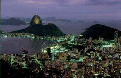
Hoje, o Estado do Espírito Santo, de frente para o Atlântico, com cerca de 500 km de costa, mantém uma vocaçăo genuinamente marítima. No litoral capixaba, está implantado o maior complexo Portuário do Brasil, a serviço da exportaçăo. Lá, operam os Portos de Vitória e Capuaba, os Terminais de Tubarăo, Ubá e Barra do Riacho. Constroi-seo grande Porto de Praia Mole. O Espírito Santo vai, assim, se constituindo no maior comp!exo Portuário da América do Sul, hoje com mais de 40% das nossas exportaçőes.
A Marinha está presente no Estado com a Capitania dos Portos, fiscalizando toda esta área de terminais, piers e atracadouros, em seu litoral. Também a modelar Escola de Aprendizes Marinheiros do Espírito Santo, preparando homens para as atividades náuticas, contribui para a boa formaçăo de marujos que,pelos continentes do mundo,mostrarăo a pujança e a capacidade da Marinha Brasileira.
A economia do Estado tem como principal fonte a cultura do café, cuja produçăo em 1980 foi da ordem de 326.570 toneladas. É seguido pela banana, cacau, laranja
The Flag consists of a white rectangle, with twenty units of length and fourteen of width, with a red equilateral triangle in the center, that has eight units on each side, presenting on the upper left side, the word "LIBERTAS"; on the upper right side the words "QUAE SERA” and on the bottom, the word "TAMEN", forming in the whole the slogan of the conspiration of Minas Gerais (Inconfidęncia Mineira).
The form and design of the flag were made on the model idealized by the leaders of the liberation movement, of 1789, which would be adopted by the Republic that they planned to create. According to what is declared by Tiradentes, the triangle reminds the Three Persons of the Trinity.
The latest description and interpretation of the Flag of the State of Rio de Janeiro is the Law No. 5.588 of October 5th, 1965. The Flag is a rectangle divided in four equal parts, by horizontal and vertical axis. The color of the Flag is celestial blue and white, alternated. The superior rectangle near the flagpole is white, the inferior blue. The other side shows the superior rectangle in blue and the inferior in white. In the center is the armor of the State, the form of which is a cut oval with elements referring to Geography, Economy and History of the State.
Nowadays, the flag is formed by thirteen horizontal stripes (7 of them black and 6 white) and a red rectangle on its superior left corner. lnside of it there is a silver circle with the geographic outline of the Brazilian Territory in blue and four golden stars on its angles.
Săo Paulo is the largest city of both South America and Brazil as well as the capital of Brazil's richest state, Săo Paulo. Located in the southeastern part of the country on the Tiete River, about 55 km (35 mi) inland from SANTOS, Brazil's principal port, Săo Paulo is the country's leading manufacturing and financial center.
Founded by Jesuits in 1554, Săo Paulo served during the 17th and 18th centuries as a base for Portuguese settlement of the interior. In 1822 it was the city in which Emperor Pedro I proclaimed Brazil's independence from Portugal. In the 1880s, Săo Paulo state became a major coffee-growing region
Designed and maintained by FLB Enterprises
![]()